
Are Pearl Oysters found in deep water?
AIMS acknowledges Yawuru, Karajarri and Nyangumarta People as Traditional Owners of the 80 Mile Beach coast and surrounding region where this work on Pearl Oyster was undertaken in the Northwest Shores to Shoals project. We recognise these People’s ongoing spiritual and physical connection to country and pay our respects to their Aboriginal Elders past, present and emerging.
Why look for pearl oysters in deep water?
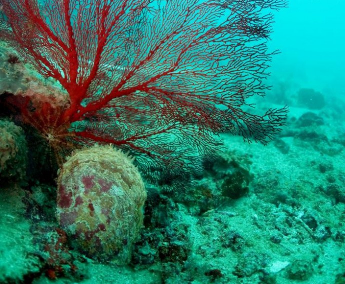
The Silver Lipped Oyster, Pinctada maxima, forms the basis of a historical fishery in tropical Western Australia, estimated to be worth $A61 million in 2013. This fishery supplies pearl and mother of pearl markets through wild harvest of P. maxima stock, augmented more recently with aquaculture. Eighty Mile Beach is a key harvesting area, where P. maxima is reported to occur at depths from 8-40 metres. P. maxima is often found where the seabed is solid and hard and can support communities of filter feeders like sponges.
Some reports, however, suggest that P. maxima can survive at depths of up to 120 metres (see p 39 in this report). Studies have shown that populations of P. maxima within the region are highly connected to one another. This raises the question of whether oysters located deeper than those safely visited by divers (beyond 30-40 metres) may help replenish stocks in shallower areas. At present, the extent to which P. maxima occurs at these depths (>40 metres) within the region near Eighty Mile Beach is poorly known.
The North West Shoals to Shore Research Program investigated seabed habitats and their biodiversity to inform management and sustainable development of the region. This information will aid in the sustainable development of the region, and can be used by regulators and mangers to inform decision making. For a region located just offshore from the Eighty Mile Beach Australian Marine Park, we aimed to:
- Map the distribution and habitat preferences of P. maxima oysters in waters deeper than those typically accessed by divers, and
- Identify the combination of a wide range of factors (depth, substrate, habitat types, oceanographic conditions) that best explain where P. maxima oysters were found in deeper waters.
What did we find?
Explore the map below to see where we looked for oysters, where we found them, and the depths at which they were recorded.
Oyster and other organism
Transect depth
Eighty Mile Beach Marine Park
To answer these questions, we collected:
- 119 towed underwater videos across 179 km of seabed
- 862 km2 of multibeam sonar, in areas from 20 to 100 metres deep
- 862 km2 of backscatter data to measure the hardness of the seabed
We took underwater photographs and video of the seafloor to detect and map the location of the oysters. We used sonar to map the depth of the seabed in high detail (measuring depth every 10 metres of distance). From the detailed depth data, we characterised the extent to which the seafloor was rugged and complex versus flat and featureless. We collected backscatter data to estimate and map the hardness of the seabed, even if covered by a layer of soft sediment. This is important because oysters must attach to a hard surface to survive.
Only 341 pearl oysters were seen out of 84,497 observations. Oysters were found at depths from 28-76 metres, but very few were found deeper than 40 metres. Watch the video below - can you spot the oysters? Also look out for the filter feeders (like sponges, gorgonians and sea whips) that are often found in the same places as oysters.
Two statistical models were built to examine the relative importance and skill of 120 factors that could potentially predict why oysters were located in some places and not others. We found that oysters were often located near filter feeding organisms, so we build a first model to predict where filter feeders were located based on depth and related measures with some success. From the first model, we predicted the likelihood of existence of filter feeders and used that in a second model with backscatter and oceanographic data to try to predict where oysters were found and where they were not found. The predictive power of the second model was very low because so few oysters were detected (<1% of all observations). A future study could collect more multibeam sonar data, use our first model to predict where filter feeders are likely to exist, and then use that as a guide to collect more towed video data to look for deep water oysters.
Metadata link: https://apps.aims.gov.au/metadata/view/0e5ca52f-5525-44da-b0ca-df758850963e
AIMS North West Shoals to Shore Research Program is proudly supported by Santos as part of the company's commitment to better understand Western Australia's marine environment.