
Baited video surveys collected for the Barossa Environmental Baseline Study 2015, Western Australia
Interactive map displays stereo-video imagery collected for the Barossa Environmental Baseline Study 2015, Western Australia. Click on the map below (i.e. the blue dots) to view short videos of the fish and benthos collected at each site. Two cameras were used to obtain accurate length measurements of the fish.
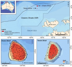
Fish surveys conducted using stereo-Baited Remote Underwater Video Stations (BRUVS) were deployed and retrieved across two shoals of regional interest, Evans and Tassie Shoals, two of the closest shoals to the Barossa field. The allocation of deployment positions across each shoal was conducted using a regular/random design within the bounds of the 60 m depth contour whilst maintaining a minimum distance of 250 m between each stereo-BRUVS unit. A total of 72 stereo-BRUVS deployments were conducted at Evans Shoal and 23 deployments at Tassie Shoal.
The BRUVS surveys were undertaken by the Australian Institute of Marine Science (AIMS) in collaboration with ConocoPhillips as part of the Barossa field environmental baseline and marine studies program. The surveys were undertaken between 13 September and 1 October 2015, on the RV Solander. They covered five principle locations of regional interest, including Evans, Tassie and Blackwood Shoals, the closest shoals to the Barossa field, as well as two mid-shelf seabed locations adjacent to Goodrich Bank and Cape Helvetius, relevant to a potential gas export pipeline route.
More information on the study can be found here