
Recent datasets
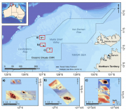
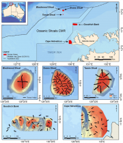
Stereo-Baited Remote Underwater Video Stations (BRUVS) were deployed and retrieved in targeted shallow seabed environments within the proposed Oceanic Shoals Commonwealth Marine Reserve (CMR) in the Timor Sea. The survey concentrated on shelf habitats (< 200m) of the western part of the Oceanic Shoals CMR and included potential biodiversity hotspots such as pinnacles, banks and shoals. In total, 56 stereo-BRUVS were deployed between 31 and 77 metres for one hour according to a regular random sampling design, with minimum spacing of 400 m to ensure independence among samples.
The dataset depicts the proclamations made under the Seas and Submerged Lands Act (SSLA) 1973. This includes the continental shelf, the Exclusive Economic Zone (EEZ), territorial sea and territorial sea baselines.
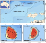
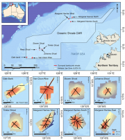
Stereo Baited Remote Underwater Video Stations (BRUVS) were deployed and retrieved across two shoals of regional interest, Evans and Tassie Shoals, two of the closest shoals to the Barossa field. The allocation of deployment positions across each shoal was conducted using a regular/random design within the bounds of the 60 m depth contour whilst maintaining a minimum distance of 250 m between each stereo-BRUVS unit. Once the positions were derived, the sequence of deployments, in sets of eight replicate units, was determined by proximity and prevailing sea conditions on the day.
Towed video surveys were carried out in targeted shallow seabed environments within the proposed Oceanic Shoals Commonwealth Marine Reserve (CMR) in the Timor Sea. The survey concentrated on shelf habitats (< 200m) of the western part of the Oceanic Shoals CMR and included potential biodiversity hotspots such as pinnacles, banks and shoals. In total, 52 towed video transects were collected at depths of between 31 and 129 metres.
Towed video surveys were carried out across five principle locations of regional interest, including Evans, Tassie and Blackwood Shoals, the closest shoals to the Barossa field, as well as two mid-shelf seabed locations adjacent to Goodrich Bank and Cape Helvetius. In total, 113 towed video transects and 2246 downward facing digital still images were collected at depths of between 11 and 100 metres.
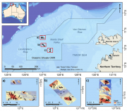
Towed video surveys between were carried out in targeted shallow seabed environments within and adjacent to the proposed Oceanic Shoals Commonwealth Marine Reserve (CMR) in the Timor Sea. The survey concentrated on shelf habitats (< 200m) of the Oceanic Shoals CMR and included potential biodiversity hotspots such as pinnacles, banks and shoals. In total, 48 towed video transects were collected at depths of between 17.2 and 89 metres.
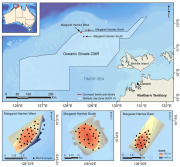
Stereo Baited Remote Underwater Video Stations (BRUVS) were deployed and retrieved across targeted shallow seabed environments within and adjacent to the proposed Oceanic Shoals Commonwealth Marine Reserve (CMR) in the Timor Sea. The survey concentrated on shelf habitats (< 200m) of the Oceanic Shoals CMR and included potential biodiversity hotspots such as pinnacles, banks and shoals.
In NW Australia a range of emergent reefs bound the western margin of the Oceanic Shoals bioregion, but with the major feature being numerous submerged shoals lying along and across the shelf edge. Scott Reef, the largest emergent reef system, has a diverse shallow water coral reef ecosystem that has demonstrated impressive resilience to cyclone and coral bleaching disturbances over the last 15 years (Gilmour et al, 2013). The adjacent deeper lagoon of South Scott Reef covers approximately 300 km2 in depths of 30-?70m.
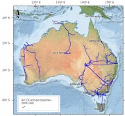
This data set contains information on Oil and Gas pipeline infrastructure. This dataset has been converted from Microstation format used in a map "Petroleum Exploration and Development Titles" published annually in APRIL. Attributes have been added to comply with data standards and minor coding of line work has been achieved using annotation from the map. Further data has been added, specifically for the specific Acreage Release Areas.