
A guide to Indigenous science, management and governance of Australian coastal waters
Understanding the management and governance of Australia’s vast coastline can be complex. International, Commonwealth, State and Indigenous entities all have various roles and powers to promote the health and integrity of Australia’s marine environments.
[Quick links: Promoting Partnerships - Maps to help you get started - Links to Indigenous Sea country Management Plans]
For Indigenous Australians, the coastlines where they live not only play a significant role in their daily lives by providing natural resources, but are also deeply embedded in their social, cultural and spiritual values. Indigenous Australians have been skilfully managing their “Sea country” for thousands of years. However, modern day coastal Australia is facing rapidly increasing pressures from many new sources. Population growth, recreational and commercial fishing, industry and the rapid development of coastal areas are all examples.
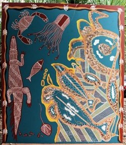
In response to today’s modern day challenges, many Indigenous groups have developed their own management goals and aspirations, many of which are synthesised in Healthy Country (see an example) and Indigenous Protected Area Management Plans (IPAMPs - see an example). One goal within most of these plans is to form strategic alliances and partnerships with other marine science and management agencies, a goal that provides everyone with the opportunity to work together for the common good. There is a shared realisation that the integration of traditional knowledge and western science provides a potent way in which to better understand our coastline ecosystems and meet these new challenges.
But how do you go about conducting science in indigenous Sea country? Who lives where? What is the status of governance? Who manages what? And with whom can we partner?
Promoting partnerships for Sea Country Research and Monitoring in Western Australia: A snapshot of Indigenous, science and management agency partners
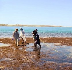
Indigenous Sea Country science managed by Land & Sea Rangers in association with one or more science, university, industry and management agencies is a growing area in the marine research and monitoring science fields. In Western Australia, these types of partnerships have grown exponentially in the last decade alongside Native Title Claims and are proving effective in delivering cross-cultural understanding in areas that include not only science but marine management, business and education sectors. In all, thirty saltwater Native Title holders and claimants, eight government agencies, four universities and various marine science and professional organisations have developed or are in the process of developing cross-cultural partnerships specifically targeting marine science projects. Alongside this positive outcome, the sharing and blending of Traditional Ecological Knowledge with western science techniques is proving to be an effective, respectful and inclusive way to acknowledge both knowledge streams.
A report titled “Promoting partnerships for Sea Country Research and Monitoring in Western Australia: A snapshot of Indigenous, science and management agency partners” provides a current state-of-affairs in listing the present status of indigenous and non-indigenous partners in science, their activities, capacity and direction in collaborative science projects on Saltwater Country in Western Australia. It uses 2019 (August) information to profile a broad range of organisations whose goals, structures, policies and programs will change with time. As such, the information in this document is expected to become progressively outdated. The report has been produced by Mosaic Environmental in conjunction with the National Environmental Science Program’s Marine Biodiversity Hub with the intention of identifying existing partners, as an aid to all interested parties in facilitating further science and management projects and in acknowledgement of the importance of working as a united front when confronting contemporary problems in today’s rapidly evolving marine estates.
When using this document, please cite appropriately and adhere to the Copyright conditions and Limitation listed below.
Citation: Lincoln G, Hedge P (2019) Promoting partnerships for Sea Country Research and Monitoring in Western Australia: A snapshot of Indigenous, science and management agency partners, Version 1. Report to the National Environmental Science Program, Marine Biodiversity Hub. Mosaic Environmental.
Copyright: This report is licenced by the University of Tasmania for use under a Creative Commons Attribution 4.0 Australia Licence. For licence conditions, see https://creativecommons.org/licences/by/4.0/
Limitations: This document should only be used for the purposes of promoting collaborative saltwater science projects between named Indigenous saltwater groups in Western Australia and those included organisations/agencies/collaborations with marine science agendas in the state.
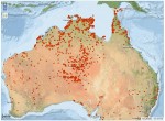
Maps to help you get started...
Below we provide links to a set of interactive maps which offer a starting point to guide scientists, managers, students and the general public to identify indigenous Sea country areas. These maps provide basic but important information and are meant to be a first step in identifying the legal framework and governance of traditional indigenous Sea country. Depending on the map, by zooming in on your geographic area of interest, information which identifies traditional ownership, representative bodies, legal status, land-use agreements, landmarks, correct names and GPS locations are all available to guide you so that you can plan ahead, make contact with the correct organisation or simply learn more about indigenous Australia. Click on each subheading below to access the relevant map.
Where does native title exist in Australia?
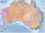
Native title is the recognition in Australian law that some Indigenous people continue to hold rights to their land and waters. It may include the right to possess and occupy an area to the exclusion of all others, or it may be a set of non-exclusive rights. There can be no native title rights to minerals, gas or petroleum recognised under Australian law. In tidal and sea areas, only non-exclusive native title can be recognised.
Where are Indigenous Protected Areas (IPAs) in Australia?
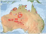
Indigenous Protected Areas (IPAs) in Australia are voluntarily dedicated by Indigenous groups on Indigenous owned or managed land or sea country. They are recognised by the Australian Government as an important part of the National Reserve System, protecting the nation's biodiversity for the benefit of all Australians. There are currently over 70 dedicated IPAs across 65 million hectares accounting for more than 40% of the National Reserve System's total area.
Where do Indigenous Land Use Agreements (ILUA) exist across Australia?

An Indigenous Land Use Agreement (ILUA) is an agreement about the use and management of land and waters made between people who hold, or may hold, native title in the area, and other people, organisations or governments. To be an ILUA, an agreement must meet with the requirements of the Native Title Act 1993.
Where do Representative Aboriginal and Torres Strait Islander Body (RATSIB) areas exist across Australia?
The National Native Title Tribunal was established by the Native Title Act 1993 to make decisions, conduct inquiries, reviews and mediations, and assist various parties with native title applications, and Indigenous land use agreements (‘ILUAs’). Australia is split into representative areas to facilitiate this.
What are the Preferred and Alternate names for indigenous locations where Australian Government programs and services have been, are being, or may be provided?
The Australian Government developed its Indigenous Programs & Policy Locations (AGIL) dataset as an authoritative source of indigenous location names across Australia. It is designed to support the accurate positioning, consistent reporting, and effective delivery of Australian Government programs and services to indigenous locations. The dataset contains Preferred and Alternate names for indigenous locations where Australian Government programs and services have been, are being, or may be provided. This dataset is NOT a complete listing of all locations at which indigenous people reside. Town and city names are not included in the dataset.
Links to Indigenous Sea country Management Plans...
Where established indigenous Sea country Management Plans are in place (view a map), you can view them by clicking on their names in the tables below. A separate table is provided for Western Australia, Northern Territory, Queensland, Torres Strait Islands, New South Wales, Victoria, Tasmania, and South Australia.
| Indigenous Protected Area | Name of plan | Document type | Time span | Source agency |
|---|---|---|---|---|
| Warul Kawa IPA | Warul Kawa IPA Fact Sheet | Fact sheet information | n/a | Torres Strait Regional Authority |
| Pulu IPA | Pulu Indigenous Protected Area Plan of Management | Indigenous Management Plan | 2009 | Pulu Indigenous Protected Area and Mabuygiw Rangers |
| Warraberalgal and Porumalgal IPA | Warraberalgal and Porumalgal Indigenous Protected Area | IPA Brochure | n/a | Torres Strait Regional Authority |
| Warraberalgal and Porumalgal IPA | Warraberalgal and Porumalgal Indigenous Protected Area | Torres Strait IPAs Fact Sheet | n/a | Torres Strait Regional Authority |
| Indigenous Protected Area | Name of plan | Document type | Time span | Source agency |
|---|---|---|---|---|
| Ngunya Jargoon IPA | Ngunya Jargoon IPA Plan of Management | Indigenous Management Plan | 2013 | Jali Local Aboriginal Land Council |
| Minyumai IPA | Minyumai IPA Plan of Management & MERI Plan | Indigenous Management Plan | 2011 | Minyumai Land Holding Aboriginal Corporation |
| Gumma IPA | Gumma Indigenous Protected Area | Fact Sheet Information | n/a | Nambucca Heads Local Aboriginal Land Council |
| Indigenous Protected Area | Name of plan | Document type | Time span | Source agency |
|---|---|---|---|---|
|
Deen Maar IPA |
Deen Maar Indigenous Protected Area | Fact Sheet Information | n/a | Framlingham Aboriginal Trust |
| Lake Condah IPA, Kurtonitj IPA & Tyrendarra IPA | Ngootyoong Gunditj Ngootyoong Mara South West Management Plan | State Management Plan | 2015 | Gunditj Mirring Traditional Owners Aboriginal Corporation |
| Tyrendarra IPA | Tyrendarra Indigenous Protected Area | Fact Sheet Information | n/a | Gunditj Mirring Traditional Owners Aboriginal Corporation |
| Lake Condah IPA | Lake Condah Indigenous Protected Area | Fact Sheet Information | n/a | Gunditj Mirring Traditional Owners Aboriginal Corporation |
| Kurtonitj IPA | Kurtonitj Indigenous Protected Area | Fact Sheet Information | n/a | Gunditj Mirring Traditional Owners Aboriginal Corporation |
| Indigenous Protected Area | Name of plan | Document type | Time span | Source agency |
|---|---|---|---|---|
| Risdon Cove and Putalina IPA | Risdon Cove and Putalina Indigenous Protected Areas | Fact Sheet Information | n/a | Tasmanian Aboriginal Centre |
| Preminghana IPA | Preminghana Healthy Country Plan 2015 | Indigenous Healthy Country Plan | 2015 | Tasmanian Aboriginal Centre |
| lungatalanana IPA, Babel Island IPA & Big Dog Island IPA | lungtalanana, Babel Island & Big Dog Island Healthy Country Plan 2015 | Indigenous Healthy Country Plan | 2015 | Tasmanian Aboriginal Centre |
| Mount Chappell Island IPA & Badger Island IPA | Mount Chappell Island and Badger Island Indigenous Protected Areas | Fact Sheet Information | n/a | Tasmanian Aboriginal Centre |
| Indigenous Protected Area | Name of plan | Document type | Time span | Source agency |
|---|---|---|---|---|
| Wardang Island IPA | Conservation Action Planning June 2015 Summary Southern Yorke Peninsula | Government Report | 2015 | South Australian Aboriginal Lands Trust |
| Yalata IPA | Indigenous Healthy Country Draft Plan | 2011-2016 | Yalata Land Management , Yalata Community Inc. |
Important...
Please read, cite and use these documents responsibly by referring to any special requirements outlined. Note that this is a rapidly evolving area with many new plans to be finalised and published shortly (here is an example). It is your responsibility to ensure that you are aware of the most up to date information.