
Modelling what substrates make up the NW shoals of the Timor Sea
Submerged reefs and shoals are important features of the North West Marine Region of Australia due to their diverse and often unique benthic (e.g., corals, sponges) and fish biodiversity. In 2009, reefs and shoals near the Montara oil field were exposed to an uncontrolled release of oil and gas that lasted for 74 days.
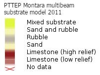
In response, PTTEP commissioned a new world class body of independent scientific research into the marine life and ecosystems of the Timor Sea. Spatial scientists at the Australian Institute of Marine Science used high resolution multibeam data collected during PTTEP-funded field surveys to predict the types and distribution of substrate that make up each shoal, as shown below:
How to use the map
| Click on this icon at the top left of the map to see a full screen version. | |
| Click on this icon also at the top left of the map to zoom in closer to (+) or further from (-) the map. |
Colours on the background of the map show the water depth (shades of blue) and land elevation (other colours) near the NW shoals. Click on the map to see the depth or elevation in any given location.