In search of the biodiversity of remote NW Australia’s Kimberley region
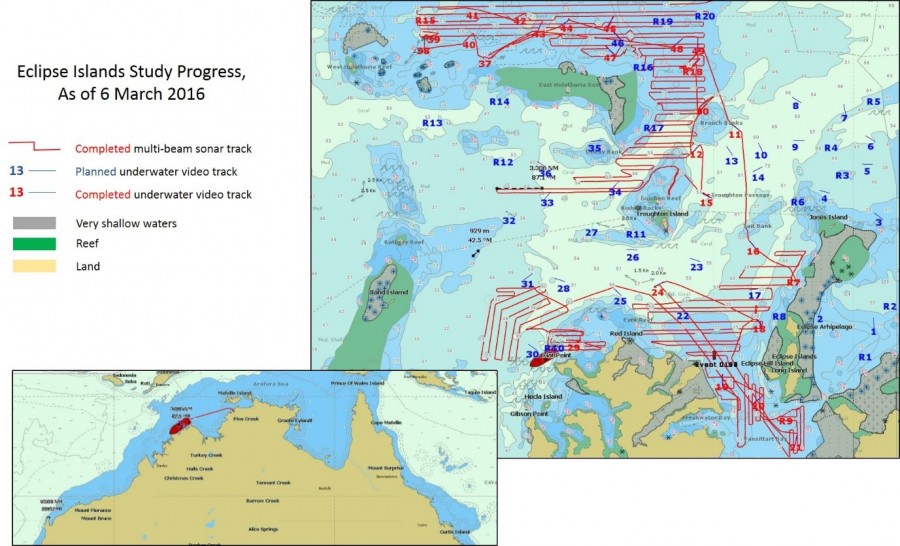
Study area for the current WAMSI campaign.
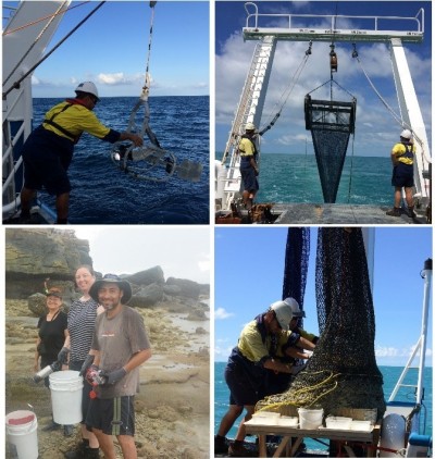
Once again, a team of scientists from the Australian Institute of Marine Science, CSIRO and the WA Museum are working with the dedicated crew of the RV Solander to explore the little known and relatively pristine tropical waters of north-west Australia’s remote Kimberly region. This is just one of several similar research expeditions conducted (or to be conducted) for WAMSI to map biodiversity in the region (see previous NW Atlas article ‘Turbid waters and exposed reefs: unlocking the secrets of the Kimberley coast’). The RV Solander departed from Darwin on 29th February 2016.
Where is the study area?
The study area for the current field campaign (see map above) is centred on the Bougainville Peninsula, stretching from Long Reef to the west, East Holothuria Reef to the north, and the Eclipse Islands to the east. This region is located just west of the Joseph Bonaparte Gulf, in north-west Australia’s remote Kimberly region. The red ship icon on the bottom map shows the location of the RV Solander in the afternoon of 6 March 2016 at the scale of Australia’s northern tropics.
What data are we collecting?
Following on from previous WAMSI field campaigns (in Camden Sound and the Bonaparte Archipelago, centred on Bigge Island), scientists and crew of the RV Solander aim to:
- Map the depth of the ocean floor at a high resolution using a dual head multi-beam sonar,
- Characterise the benthos using towed video along a 1.5 km transect for at least 50 sites (real-time assessment of community types, later assessment of infauna genera and species),
- Estimate species biodiversity by taking bottom samples of infauna along a 50 to 100 metre transect (sled) for each of at least 25 of the towed video sites, and
- Sample shallow water habitats inaccessible by the RV Solander via two reef walks.
We also periodically measure water conductivity, salinity and temperature and take grab samples of the bottom.
What have we done so far?
As of 6 March 2016, we completed 31 towed video transects, 10 sleds, and 1,300 km of multi-beam swaths across the study region (see map above).
- Watch the video below to see an example of medium to high density filter feeder communities on the north-western corner of East Holothuria Reef (towed video transect # 37).
- Watch the videos below for a close-up look at some of the many jellyfish we’ve observed so far on our journey, both with the towed video and live specimens.
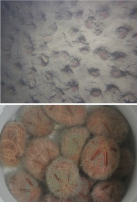
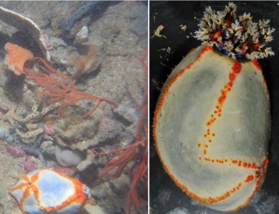
- Above is an example of a sea cucumber as observed in a still photo taken in situ by the AIMS towed-video, and a picture of the actual sea cucumber once retrieved by the sled on the same transect.
- Specimens collected via the sled can help confirm observations apparent from the towed video still images. For example, in the top image below (still photo from towed video underwater camera) suggests that a series of burrows were created by a type of heart urchin. A sled sample of the same transect collected several heart urchins (bottom photo) which are known to create such burrows.