
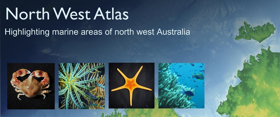
North West Atlas home page
RECENT RESEARCH
 26 May 2022
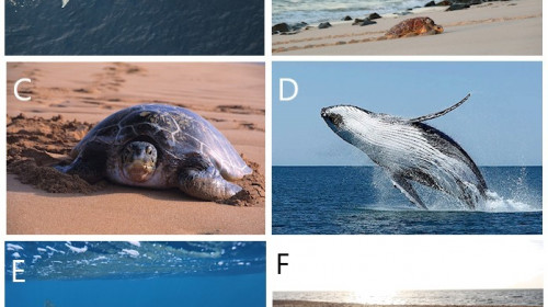
Mapping exposure of marine megafauna to anthropogenic threats in the north-west marine region of Australia
We used data from satellite telemetry tags attached to six species of threatened and migratory marine megafauna across three taxonomic groups (marine turtles, whales and sharks) off the coast of north-western Australia to map their areas of use. We then compiled spatial data from a range of threats and overlayed species and threat maps to assess the level of exposure of the species to threats. In doing so we can identify areas where there is high exposure of species to threats, where risk assessments can be best directed with resulting management actions if needed in order to protect these species.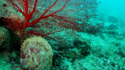 26 May 2022
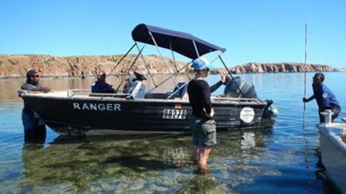
How connected are deep and shallow Pearl Oysters in the Eighty Mile Beach area?
We use genetics to estimate how far and wide oyster larvae can disperse to assist in setting biologically relevant spatial boundaries and harvest limits for oysters.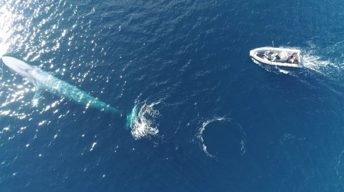 26 May 2022
Distribution and important areas for pygmy blue whales
To assist in recovery of the population, spatial areas of importance to pygmy blue whales, known as Biologically Important Areas (BIA), have been identified by the Australian Government. The AIMS team and collaborators Centre for Whale Research and Curtin University set out to reduce uncertainty in identifying where important foraging areas for this species and their migration pathways and distribution exist, and the extent to which they overlap with anthropogenic activities by deploying satellite tags.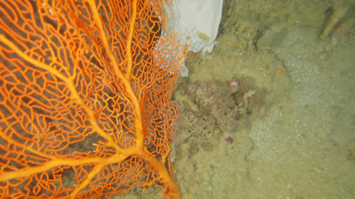 26 May 2022
Discovering what lives on the sea floor at 125m depth
Key Ecological Features (KEFs) are parts of the marine ecosystem considered to be of particular importance for either a region's biodiversity or its ecosystem function and integrity. 13 KEFs have been defined for Australia’s North-west Marine Region, including the ‘Ancient Coastline at 125m depth contour’ (AC125). The AC125 is thought to “provide areas of hard substrate and therefore may provide sites for higher diversity and enhanced species richness relative to surrounding areas of predominantly soft sediment.” Little is known about what habitats exist on the sea floor in the AC125. Part of the reason is that the AC125 is very deep, and thus difficult to observe. The North West Shoals to Shore Research Program took underwater photographs and video of the seafloor to better understand each AC125 Area within its local context.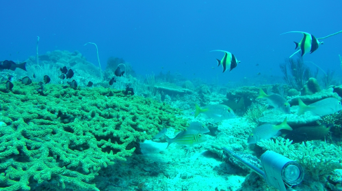 17 March 2021
Money Shoal, Arafura Marine Park, Australia
The information in this eco-narrative forms an initial characterisation of the physical, oceanographic and biological character of Arafura Marine Park, with a focus on results from a biodiversity and mapping survey undertaken by the NESP Marine Biodiversity Hub in 2020. This survey targeted two areas (see map below): Money Shoal as an example of shallow coral reef habitat, and Pillar Bank as an example of a deeper water mixed seabed environments. This excerpt focuses mainly on Money Shoal.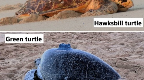 11 June 2020
Hawksbill and green turtle distribution and important areas
Global populations of green (IUCN listing endangered) and hawksbill (IUCN listing critically endangered) turtles are declining due to a range of threats. Australia supports some of the largest rookeries (nesting sites) for these turtles in the Indo-Pacific. Even though they've been much studied, most data that shows where these turtles spend their time around Australia remains unpublished. Here, we set out to quantify and map the important areas that turtles use to help refine these protected areas and assist with turtle conservation management.- 9 June 2020
Are Pearl Oysters found in deep water?
The Silver Lipped Oyster, Pinctada maxima, forms the basis of a historical fishery in tropical Western Australia, estimated to be worth $A61 million in 2013. This fishery supplies pearl and mother of pearl markets through wild harvest of P. maxima stock, augmented more recently with aquaculture. Studies have shown that populations of P. maxima within the region are highly connected to one another. This raises the question of whether oysters located deeper than those safely visited by divers (beyond 30-40 metres) may help replenish stocks in shallower areas. At present, the extent to which P. maxima occurs at these depths (>40 metres) within the region near Eighty Mile Beach is poorly known. 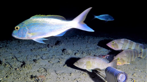 9 June 2020
How many different species of fish are found around the Ancient Coastline (125m) KEF?
The North West Shoals to Shore Research Program investigated seabed habitats and their biodiversity to inform management and sustainable development of the region. Little is known about the fish found on and around the AC125. Part of the reason is that the AC125 is very deep, and thus difficult to observe. One question to ask about a habitat is how many different species of fish are found there - this is called fish species 'richness'. We explored this question for 5 study areas spread along the vast AC125 (see map below, read the full paper here).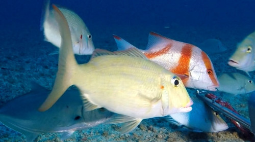 4 June 2020
Finding fish on the Ancient Coastline KEF (125 m) with underwater video
Little is known about what fish species call the AC125 home. Part of the reason is that the AC125 is very deep, and thus difficult to observe. To fill this gap, we conducted fish relative abundance and diversity surveys across five study Areas of the AC125 using Baited Remote Underwater Video Stations (BRUVS). BRUVS were deployed on and off the AC125 at a minimum distance of 500 m between each unit. A total of 204 BRUVS deployments were conducted at depths between 62.1 m and 181.4 m across each study Area from the RV Solander.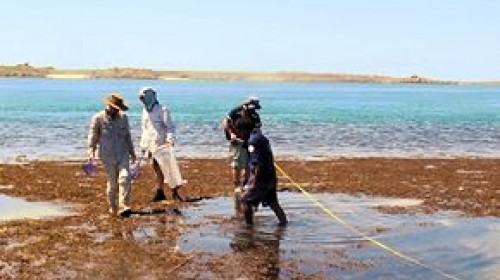 5 February 2020
A guide to Indigenous science, management and governance of Australian coastal waters
Understanding the management and governance of Australia’s vast coastline can be complex. International, Commonwealth, State and Indigenous entities all have various roles and powers to promote the health and integrity of Australia’s marine environments.
 16 December 2019
Indigenous partnerships in marine science
Bardi-Jawi Marine Rangers partner with marine scientists to research fish and coral recruitment processes in the Kimberley. 23 November 2018
Sponge functional growth forms as a means for classifying sponges without taxonomy
Sponge taxonomy is difficult and challenging, it requires adequate laboratory facilities, experience and time, which are often not available. Moreover, not all habitats can be physically sampled (e.g. protected areas, deep sea), and for monitoring purposes video work is usually the preferred method. However, sponges cannot reliably be identified from imagery lacking samples, and therefore we recommend using growth forms as a quick classification. If the growth forms are described by clearly focusing on their function, they will represent environmental conditions, e.g.
 13 April 2018
What do we know about the Glomar Shoal Key Ecological Feature?
Learn more about the Glomar Shoals KEF, based on new knowledge of its benthic and pelagic environments that researchers within the NESP Marine Biodiversity Hub used to develop a preliminary model of the KEF's ecosystem components and processes.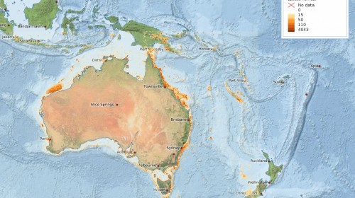 12 December 2017
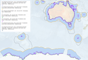
Species Richness
Species richness is a count of the number of different species that exist in a given region or ecological community. It is one of the simplest ways to describe community and regional diversity and is commonly used for a range of environmental assessments in conservation and management.
Use the interactive map below to discover which areas around Australia have high and low species richness.
 12 December 2017
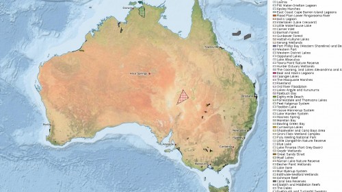
Ramsar Wetlands of International Importance
Wetlands are a critical part of our natural environment. They protect our shores from wave action, reduce the impacts of floods, absorb pollutants and improve water quality. They provide habitat for animals and plants and many contain a wide diversity of life, supporting plants and animals that are found nowhere else. The Convention on Wetlands of International Importance (the Ramsar Convention) was signed in Ramsar, Iran on 2 February 1971. The Ramsar Convention aims to halt the worldwide loss of wetlands and to conserve, through wise use and management, those that remain.
 11 December 2017
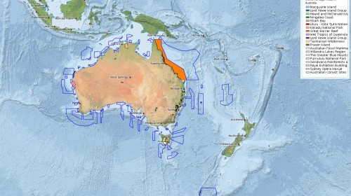
World Heritage Areas
World Heritage Areas are places that are considered to be of outstanding value to humanity. Their aim is to protect natural and cultural heritage, and listed sites are places that belong to all the people of the world irrespective of their location. Sites that are nominated for World Heritage listing are only inscribed on the list after they have been carefully assessed as representing the best examples of the world's cultural and natural heritage.
 7 December 2017
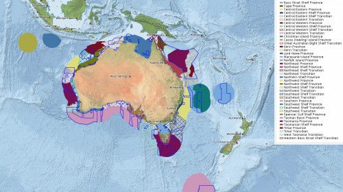
IMCRA Provincial Bioregions
The Integrated Marine and Coastal Regionalisation of Australia (IMCRA v4.0) classified Australia's marine environment into ecologically relevant bioregions for regional planning. These bioregions are the basis for the development of a National Representative System of Marine Protected Areas (NRSMPA).
 7 December 2017
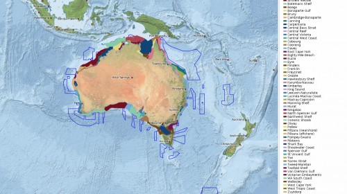
IMCRA Mesoscale Bioregions
The Integrated Marine and Coastal Regionalisation of Australia (IMCRA v4.0) classified Australia's marine environment into ecologically relevant bioregions for regional planning. These bioregions are the basis for the development of a National Representative System of Marine Protected Areas (NRSMPA).
 7 December 2017
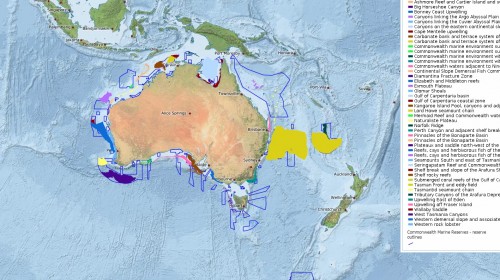
Key Ecological Features
The Key Ecological Features (KEFs) are parts of the marine ecosystem that are considered to be of particular importance for either a region's biodiversity or its ecosystem function and integrity. This could relate to a species integral to a community (e.g. a predator that impacts a large biomass or number of species), an important habitat type (e.g. that supports high productivity or aggregations of nesting or breeding animals), or a unique seafloor feature that positively impacts the surrounding ecosystem (e.g. a deep canyon that stimulates upwellings of nutrient rich water).
Announcements
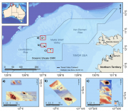
Stereo-Baited Remote Underwater Video Stations (BRUVS) were deployed and retrieved in targeted shallow seabed environments within the proposed Oceanic Shoals Commonwealth Marine Reserve (CMR) in the Timor Sea. The survey concentrated on shelf habitats (< 200m) of the western part of the Oceanic Shoals CMR and included potential biodiversity hotspots such as pinnacles, banks and shoals. In total, 56 stereo-BRUVS were deployed between 31 and 77 metres for one hour according to a regular random sampling design, with minimum spacing of 400 m to ensure independence among samples.
The dataset depicts the proclamations made under the Seas and Submerged Lands Act (SSLA) 1973. This includes the continental shelf, the Exclusive Economic Zone (EEZ), territorial sea and territorial sea baselines.
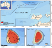
Stereo Baited Remote Underwater Video Stations (BRUVS) were deployed and retrieved across two shoals of regional interest, Evans and Tassie Shoals, two of the closest shoals to the Barossa field. The allocation of deployment positions across each shoal was conducted using a regular/random design within the bounds of the 60 m depth contour whilst maintaining a minimum distance of 250 m between each stereo-BRUVS unit. Once the positions were derived, the sequence of deployments, in sets of eight replicate units, was determined by proximity and prevailing sea conditions on the day.
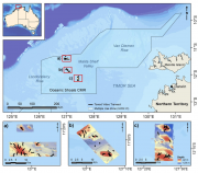
Towed video surveys were carried out in targeted shallow seabed environments within the proposed Oceanic Shoals Commonwealth Marine Reserve (CMR) in the Timor Sea. The survey concentrated on shelf habitats (< 200m) of the western part of the Oceanic Shoals CMR and included potential biodiversity hotspots such as pinnacles, banks and shoals. In total, 52 towed video transects were collected at depths of between 31 and 129 metres.