Probability of existence of benthic habitat classes across the Oceanic Shoals Commonwealth Marine Reserve
Environment Australia is tasked with managing the networks of Commonwealth Marine Reserves (CMRs). This is particularly challenging for the CMRs in the remote and poorly known N and NW regions, such as the Oceanic Shoals. Multiple field campaigns have collected high resolution survey data in the region (see 'What do we know about the Oceanic Shoals Commonwealth Marine Reserve?').
Researchers from Australia's National Environmental Science Program's (NESP) Marine Biodiversity Hub's D1 project used this data with regional scale topography data to predict the probability that each of 11 broad classes of benthic organisms exists across the CMR:
- Alcyons,
- Burrowers and crinoids,
- Filterer dominated,
- Gorgonians,
- Halimeda,
- Hard Coral dominated,
- Macroalgae dominated,
- Soft Coral dominated,
- Seagrass,
- Sponge, and
- Whips.
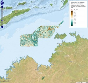
We also modelled the probability across the study area of not being able to determine a benthic class (class 0 - indeterminant). To the left is an example of what the map looks like for sponges. Read an overview of how we created these maps.
Click on the links in the table below to see interactive maps showing the probability that each benthic class listed above exists across the Oceanic Shoals CMR. Values in these maps range from 0 (benthic class does not exist - dark brown) to 1 (100% chance that the benthic class exists - dark turquoise). Note that more than one benthic class can exist together in a given location as you compare the maps.
How to use these maps
| Click on this icon at the top left of the map to see a full screen version and to see the legend. | |
| Click on this icon also at the top left of the map to zoom in closer to (+) or further from (-) the map. |
Click anywhere on the map to find out the probability of existence of the relevant benthos at that location. The value listed under 'GRAY_INDEX' is the probability.